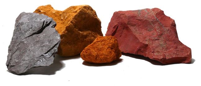
There were five main types of minerals extracted in South Gloucestershire.
By Alex Lowe
What is Celestine
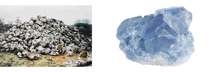
Sometimes called ‘spar’, but more correctly ‘celestite’ or ‘strontianite’, celestine is strontium sulphate, chemical symbol SrSO4 (SrOSO3 – Sr=Strontium, O=Oxygen, S=Sulphur). The element Strontium is named after Strontian in Argyllshire, where the mineral was first identified, in 1787. It is a crystalline mineral whose name ‘celestine’ comes from the Latin ‘caelestis’, meaning, roughly, ‘heavenly’, perhaps because of the sparkling white appearance of this type of quartz. It has a melting point of 1,600°C and is insoluble in water.
Where does it occur
Celestine occurs in nodules in Palaeozoic rocks worldwide, from Australia, Germany, Mexico, North America, Sicily and Spain, but the Yate area had the biggest and highest quality concentration.
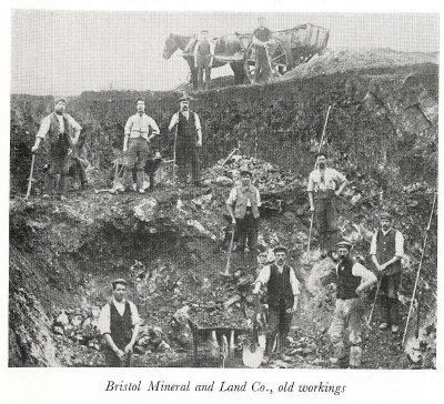
Celestine Mining in the late 1800s
When was it mined
The Board of Trade records celestine exports in the 1880s; commercial quarrying for the mineral ended in 1994, and in 1995, the processing plant operated off Tanhouse Lane by the Bristol Mineral and Land Company Limited closed. Local deposits had been worked out, consequently foreign celestine, despite its inferior quality, became competitive. So great was the value of local celestine that even the chance of finding it was sufficient reason for the Planning Committee to block Sodbury Rural Council’s proposal to build housing on the former Yate aerodrome, in 1949!
What was it used for
In the 1890s, it was bought in bulk by German sugar refineries for use in extracting sugar from sugar beet. Later, strontium compounds found a huge variety of applications, in pyrotechnics (e.g. fireworks and flares for a bright crimson flame), television screens and tubes [as a phosphor], electrical capacitors and valves, paint filler and whitener, anti-corrosive primers, chrome-plating and metal-purifying, medicines, toothpaste and depilatories, plastic and rubber fillers and PVC plastic stabilisers, caustic soda production, artificial gemstones and fertilizer.
How was it mined
At first picks and shovels were used, and the possibility of mechanisation was discounted because labour was cheap and plentiful (celestine was worked part-time, by agricultural labourers paid according to the amount they dug). Buyers also believed that mechanical mining would produce poorer quality material (lacking the workman’s discriminating eye), and farmers feared that it would damage soil fertility.
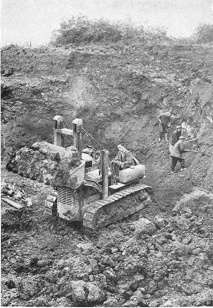
Celestine working in Yate area – Bristol Mineral & Land Co -circa 1950
However, in response to labour shortages after The Second World War, the Bristol Mineral and Land Company introduced mechanical excavators, bulldozers and pneumatic drills (to break very large nodules). Topsoil was replaced after a deposit was worked out, so fertility was unaffected.
How was celestine ore prepared for use
Before mechanization, celestine ore was transported by horse and cart to railway stations, such as the one at Wickwar, and sent for processing. Following the investment by the Bristol Mineral and Land Company, celestine was mechanically crushed, washed, ground, graded and bagged at Yate.
Who sold it
Some landowners in the late 19th Century quarried celestine piecemeal, such as the Rector of Yate, the Reverend Mr Pontifex, (he mined the Church’s land until it found out!), or Robert Drew at Wickwar. Soon after, various celestine brokers set up in business, buying from landowners and selling material on, or even buying land to quarry themselves. The Bristol Mineral and Land Company Limited were established in 1910 as a brokerage. One of its directors, Mr.Pauli, was connected with the German sugar beet refineries, and his family remained in the firm for three generations.
Further Information
Further information on local celestine quarrying can be found in our publication ‘Celestine’ in the Books Section. Shortcut to the Books section.
An Overview of Coal Mining in South Gloucestershire
By Steve Grudgings & David Hardwick
Location
The coalfield in South Gloucestershire is in effect the northern section of the Bristol and Somerset coalfield running from Cromhall in the North to Radstock in the South. Whilst the coal industry was never the predominant employer in our area in the same way as it was in the Rhonda or South Yorkshire, it was nevertheless very important locally.
You have only to look at the local geological maps to realize the number and density of the coal workings.
The coalfield extends into Bristol and under beyond the river Avon into Somerset. Distinct areas of working can be identified:
- Yate and District
- Coalpit Heath and District
- Shortwood & Pucklechurch
- Siston & Warmley
- Oldland Common & District
- Hanham & Eastern Kingswood
- Soundwell & Mangotsfield
- North Bristol & Fishponds
- Speedwell & St George
- Easton & Whitehall
- South Bristol
Further afield and now separated (but perhaps once originally part of the same area) are:
- The Nailsea Coalfield
- Bath/Twerton region
- Somerset Coalfield
- The Forest of Dean
History
The earliest records currently known to exist are licences issued to dig for coal in Kingswood Chase in the thirteenth century. The early workings were shallow, rarely exceeding 100 feet in depth until the introduction of the Newcomen steam pumping engine from about 1750 on. The industry flourished in the early part of the 19th century up to the arrival of main line railways. These were a mixed blessing providing both a route to export coal but also for imports from other areas such as the Midlands and South Wales. The quality of the local coal was, in some cases, such that even though it was harder to work than areas where the seams were thicker it was still profitable. Westerleigh coal in particular being remarked upon for it’s suitability as a steam coal.
The Last collieries
The last deep pit to close in South Gloucestershire was Frog Lane at Coalpit Heath in 1949. There was an attempt by the National Coal Board to work a drift mine at Harry Stoke, which operated from 1959-1963 but closed due to difficult ground conditions.
What Remains
In many ways we are fortunate that the local mines closed so long ago that much of the remaining buildings passed into agricultural use and survived in some form rather than being demolished and the site cleared as has happened with more modern pits. Whilst by definition the majority of remains are underground, these surface remains were one of the main prompts for the establishment of the SGMRG in 2001 and recording and preservation works have been carried out on several sites since.
The most obvious features are to be found around Parkfield (chimneys, spoil heaps and engine houses), Ram Hill and Henfield (dram-way and engine houses), Engine Common in Yate (engine houses and spoil heaps) and Cromhall Common. (engine house). At Rangeworthy there is also the Oldwood Pit site where the SGMRG periodically hold open days.
PLEASE NOTE – most of these sites are on private land. If you want more information about access etc please make contact using the contact page of this website.
What also survives is the ‘folk memory’ of local mining. The SGMRG have launched a joint Oral History Project with the Yate Oral History Project and are recording memories of miners, relatives and those connected with the industry locally. If you know of an ex-miner or someone with interesting information who would be willing to be interviewed, please make contact.
Other websites covering the extended coalfields of the West are:
- The Nailsea Coalfield – Nailsea & District Local History Society
- Bath/Twerton region – Twerton History
- Somerset Coalfield – Radstock Museum
- Trade Union Ancestors (Somersetshire Miners Association)
- The Forest of Dean – Forest of Dean Coal Mining pages
- Forest of Dean Local History Society
FURTHER INFORMATION
Further information on local coal mining can be found in our books section, where several publications are available. Shortcut to the Books section.
Many types of metal were mined in South Gloucestershire, Including:
- Iron mining
- Lead, Zinc & Silver mining
Iron mining
By David Hardwick
Iron Mining has been carried out in South Gloucestershire from an early date. It is has been suggested that iron has been worked locally since Roman times as iron slag from processing the ore is often found at Roman sites in the area. Certainly the origins of iron mining date back to before the Norman Conquest as it is referred to in the Domesday Book. The legacy of the industry is found in local names such as the village of Iron Acton and Iron Hogg Lane in Falfield. Areas that have been mined for the brown haematite iron ore include, Frampton Cotterell, Pucklechurch and Rangeworthy.
Early workings would have been surface workings with the ore smelted in charcoal fired bloomeries to extract the iron. Evidence of cinders from these can still be found and were extensive around Iron Acton and Pucklechurch indicating the scale of these early operations. The name Sinder Ford appears as the name of a crossing of the Frome in Frampton Cotterell in a Saxon Charter of about 950 AD. Also in Frampton Cotterell is an area that used to be called Furnace Hill.
During the mid nineteenth century an extensive mine existed in Frampton Cotterell. Iron Ore was extracted from a nearly vertical vein with at least 4 levels being worked down to a depth of 120 yards. The mine, however suffered difficulties with flooding. It had pumping engines and to provide the steam for these it sunk it’s own coalmine at Rangeworthy. These pumps removed 3000 gallons of water per hour. Such was the extent of water ingress that when mining ceased the site was used by the Bristol Waterworks Company as a water supply with the water being pumped to a reservoir at Tormarton.
Various names occur in relation to this mine. In the 1860’s the mine is owned by Thomas & George Barker of the Chillington Iron Works Wolverhampton. In 1867 the Victorian industrial entrepreneur John Crossley of the family of Halifax Carpet makers is the leaseholder along with Edmund Lloyd Owen who was also the manager. In 1871 three brothers named Brogden took over the lease.
Conditions in the mine could not have been pleasant with the damp and dangerous conditions and the ever-present threat of water ingress. In 1873 the foreman Silas Dando was killed when he fell down a shaft. Delays from the need to repair pumps damaged by the grit in the water must have had an effect on the profitability of the mine.
The most ore extracted in a single year was in 1870 when over 15,000 tons appears on the mineral statistic. At that time the site had its own branch line from Frampton Cotterell to Iron Acton where it connected to the Midland Railway line from Yate to Thornbury. Ore was being sent to the iron works at Seend in Wiltshire. The last recorded year of extraction is 1875.
Local Iron Mines
Lead, Zinc & Silver mining
By David Hardwick
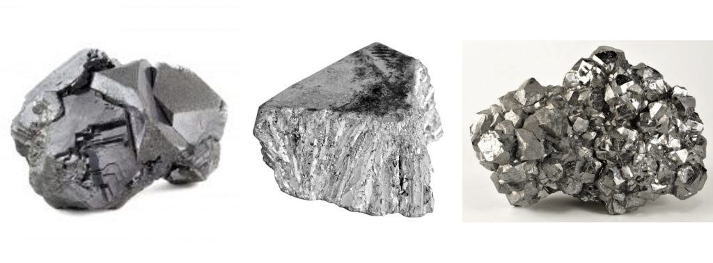
Lead in the form of argentiferous galena is found in much of South Gloucestershire and the Bristol area. Calamine (the ore for Zinc) has also been found and worked. Traces of old lead workings exist on the Durdham Downs in Bristol but also along the limestone ridge through Almondsbury up to Tortworth and round to Yate. Early references to Lead mining include a Saxon charter for the area that includes Penpark dated 882 AD which mentions “leadgedelf” of lead-diggings. There are later references to lead mining in the area with the discovery of the cavern Pen Park Hole in 1669. .Samples were taken at various dates and there is evidence of a short period of working in the nineteenth century, but this cavern is now believed to be essentially natural rather than “an olde Lead Ore Pit” as it was described in 1678.
The lead mines of Almondsbury were however perhaps more extensive. Mines were worked by a Mr Freeman in 1775 but apparently not in payable quantities. Quarrying of the limestone would have exposed the ore, which would then have been worked from the surface. It would appear that further works were carried out in the nineteenth century as shafts are marked on early ordnance survey maps and older residents have recalled walking along old tunnels when they were little for considerable distances.
It is a local legend that the lead of the church spire is from the local mines. The spire is 70 ft high and although the tower dates from the 13th century the date of the spire is not known. A plaque in the church indicates that when the spire was restored in 1925 under the direction of the architect P Hartland Thomas the lead was recast and at that time the date 1619 was found on the lead. If the original lead is from local mines it suggests an early date for workings. The date 1864 was also found on the lead so perhaps the legend comes from tales of local lead being used for repairs at that time.
The 1850 Mining Journal contains details of the proposed lead mines at Itchington near Alveston. Quarrying for limestone had exposed ore at the junction of the Limestone with the red marl and Sandstone. When samples were tested it was found that they contained 55-60% lead and 68-71 ounces of silver per ton of ore. The “Itchington Hill Silver-Lead Mining Company” was formed as a “cost book company” – i.e. where shareholders liability is limited to the value of their shares. There were originally 3072 shares at an original value of £3 each. The location of the mine at the foot of the hill suggested expensive machinery would not be necessary and a large return was anticipated The 1851 census for the area confirms that miners came from Yorkshire and Cornwall to live and work there but the mines appear to have had a short life.
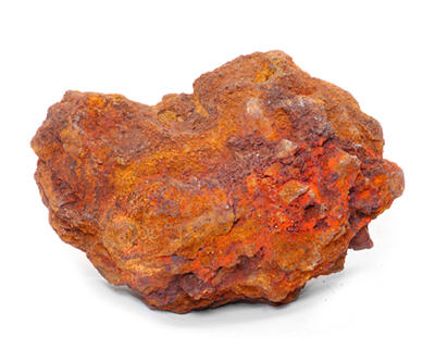
Ochre
By Jack Randell
Ochre is a hydrated oxide of iron, occurring typically in pockets of soft clay-like material. Normally of a deep red colour, it can occur in various colours, from yellow, through red, to brown. It often occurs in conjunction with other iron ores, e.g. haematite.
Ochre has been used by man as a pigment for many thousands of years, often turning up on archaeological sites. More recently, it has found use as a pigment in paints and dyes. It is the ‘red ochre’ or ‘yellow ochre’ we found in our paint boxes at an early age.
In addition to its use as a pigment, ochre is also used as an iron ore. The actual use of the ore is determined by its quality and colour.
Ochre was mined at several places in the region. There were many mines in the Mendips, including those at Axbridge (ST431 551), Compton Martin (ST541 567) Hutton (ST360 581), and Winford (ST534 637), all of which still have underground passages accessible to cavers.
In the Forest of Dean iron mines, both haematite and ochre were worked. However, the ochre would have mainly been used for iron production rather than as a pigment. An example is Clearwell Caves (SO577 082), formerly mining ochre, and now a show mine.
Nearer to hand, Golden Valley at Wick (ST706 732) is the site of an ochre works, most of whose production (at least latterly) was used for pigment. Initially the ochre was mined at the site, but latterly most of the ore was imported (e.g. from Mendip) for processing. There was an iron works in the valley as early as 1761, and the ochre works finally closed in 1968.The site is now a nature reserve, but some of the processing sheds and various other features can still be seen, and there are useful information boards detailing the industry and nature.
Stone “Mining” / “Quarrying”
The soft oolitic limestone used extensively for building stone and typical of Bath and many other Georgian towns was extracted extensively in the hills around Bath. It was also worked in other areas of the Cotswold hills including in South Gloucestershire.
Due to the nature of this material, it is often better cut from sub-surface works rather than opencast extraction and even though they are underground these would have been known as “quarries” rather than mines.
Definition: “Mining” is the removal of minerals (in general these need to be processed and it doesn’t matter too much if it gets pulverised during mining) “Quarrying” is the removal of stone (which usually needs to be kept in decent sized bits e.g. for use in building). The men who worked the stone were quarrymen, some of them just happened to work in the dark.
For further information use the links below.
Underground Stone Quarries in South Gloucestershire:
Surface Stone Quarries in South Gloucestershire:
- Carboniferous Limestone
- Sandstone
- List of operating quarries and recent closures